Well after our chance encounter with the SpaceX Starlink satellites yesterday, Monday, November 11, as described in the blog post of November 12, we were hooked and wanted to try to find the next visible transit. This post shows some successful images of the next transit and some other technical details about the future Starlink constellation of satellites.
First up, was trying to figure out when the constellation of 60 satellites would pass overhead again. We knew from previous searches for details of the Starlink project, that the satellites would not remain for a long time in the long string of lights configuration because as soon as SpaceX had verified that all of the satellites were functional they would have been commanded to move to their pre-determined orbits.
To find when the next pass over our neighborhood was going to be, we could have gone to NORAD to get the Keplerian orbital elements and then calculated when the satellites would be overhead, but there is an easier way to get the next transit. Many websites calculate transits of satellites and the Heavens Above website already provided a convenient tool for calculating transit times based on your observing location. So for the Orange County area, the website generated the following transit table. For you early risers, the transits on November 20 and 21 look pretty good, starting at 5:39 AM. For those located outside of Orange County you can use the website to calculate transits for your particular location.
 |
| Predicted Orange County sky location for the Starlink satellites (Source: Heavens Above) |
Hey, with this table in hand, it turned out that the next visible transit was going to be this evening, November 12. Pretty neat! So, the only required preparation was to get out the camera and tripod and scope out a good observing site that had mostly clear line of sites along the direction of the transit scheduled to start at 5:28 PM PST. Remember too that the list times are based on 24-hour clocks and the predicted transits on November 20 & 21 are at 5:39 AM.
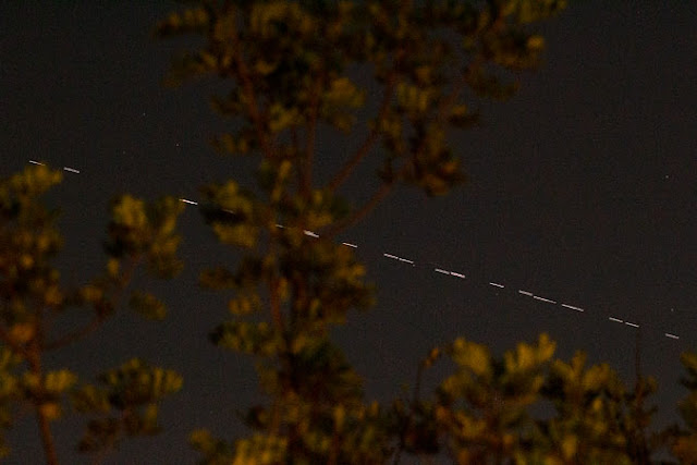
I elected to use a 150mm setting on the DSLR telephoto lens, which seemed to be a good compromise between trying to capture the whole constellation of 60 satellites. At about 5:30 PM PST, I was set up and ready to go and focused the lens using Saturn and Jupiter. My line of site was pretty good, with observations down to about 10 degrees elevation and viewing clear from the west to the south, except for some nearby trees. The indicated visible magnitude of 5.2 had me a bit worried, so I selected 0.5 second exposure with ISO set to 3200. As it turned out, 0.5 seconds was a bit too long, but I was more worried about missing the satellites because they might be too dim for shorter exposure times. I also used a red dot finder to point the camera once I had spotted the satellites visually. I spotted the satellites early on, which was quite surprising because the estimated magnitude of 5.2 was quite dim and I didn't know if I would be able to see anything dim from my city lights viewing position. But everything worked out pretty good, even though the trees managed to get in the way!
 |
| The Starlink satellites show up as a string of lights in this 0.5 second, 150mm DSLR image (Source: Palmia Observatory) |
You can see that the satellites seem to be arranged in bunces with some space in between. The exposure time was a bit too long and maybe setting the exposure to 1/4 second would be a better option for the next transit opportunity. Also that darn tree was just in the wrong place too! Ok, ok, I could have looked around for a better location also!
 |
| Another view of Starlink satellites as a string of lights in this 0.5 second, 150mm DSLR image (Source: Palmia Observatory) |
Then within just a couple of minutes, the string of lights had become too dim to see with the naked eye, but I tried one more attempt with the camera. This time the exposure was increased to 4 seconds and the camera pointing adjusted to just a bit to the left of where the string was last seen. Hooray, the string of satellites still shows up in the longer exposure image.
 |
| One last 4-second exposure to capture the now out of sight Starlink constellation (Source: Palmia Observatory) |
So, we still have potential future dates to photograph the satellites as they pass overhead. While we wait for that future time, let's dig a little deeper into the nature of the engineering and permitting of the Starlink constellation of wireless internet satellites. Remember that the purpose and business plan of the constellation is to offer low cost internet connectivity around the world. This image below shows how the constellation of satellites can cover an area of the Earth like Africa.
 |
| The Starlink constellation of satellites offers internet connectivity around the whole Earth (Source: Starlink/NextBigFuture) |
Another great YouTube video that covers some of the business planning and FCC approval for launching the Starlink constellation of satellites is the one show below and referenced at: https://www.youtube.com/watch?v=T6mdEg-1ROI
There are many other articles on Starlink and SpaceX entry into this market available for those who are looking for more of the details. For me, this search to understand Starlink, after our initial witnessing of the Starlink satellites orbiting overhead presented us with the opportunity, has already been a very interesting follow up on that initial observation.
 |
| Some engineering and FCC approval details for Starlink (Source: https://www.youtube.com/watch?v=T6mdEg-1ROI) |
Until next time (keep looking up to the sky; who knows what you will find?),
Resident Astronomer George
If you are interested in things astronomical or in astrophysics and cosmology
Check out this blog at www.palmiaobservatory.com

No comments:
Post a Comment